ADS8: Data Matter – The Gaming Edition

Lena Geerts Danau

Lena Geerts Danau is graduating from the Royal College of Art with a Masters in Architecture. She completed her BA Architecture degree at the University of Antwerp in 2018 and went on to Norway where she studied for one semester at the Bergen School of Architecture. In 2019 she came back to Antwerp and worked at the architectural practice B-architecten.

At the RCA, Lena’s research explored the geopolitical and geographical influences in the Arctic region. In ADS7: Politics of the Atmosphere, her project -Data sensing; the contemporary version of extraction- explored the geopolitical effects of data distribution. As part of the studio she took part in the Sky River installation over the summer of 2020. This was a digital and physical installation, led by Elise Hunchuck, Marco Ferrari and Jingru (Cyan) Cheng and part of the exhibition Critical Zones: Observatories for Earthly Politics, which was on display at ZKM | Center for Art and Media Karlsruhe, Germany.

This year in ADS8: Data matter – The gaming edition, led by Ippolito Pestellini, Kamil Hilmi Dalkir and Rhiarna Dhaliwal, Lena has continued her interest explored within her dissertation, a paper in which she used the Arctic region to address that a nation can have a geographical context along with a political, and explores how we could link global processes caused by the climate with their local manifestations. Within her most recent project -Alternative Arctic Perception- she searched for an alternative representation of fluid border situations emerging through political and geographical manifestations in the Arctic region.

Currently, Lena and Andra Pop-Jurj are part of the scientific and artistic collaboration Driving the Human - a catalyst for experimentation which combines transdisciplinary expertise in shaping sustainable and collective futures. Building on their MA theses, their collaborative proposal is concerned with environmental politics at a geopolitical level and envisions alternative modes of engagement across species. It will be on display in October at radialsystem, Berlin.

Lena Geerts Danau

Lena's project -Alternative Arctic Perception- started from studying the political divisions of earthly territories -land, sea, and air among them- each of these arrangements follows a particular and evolving geometry of sovereign space and a specific topology of segmentation and jurisdiction. But today’s political and geographic conflicts are often defined as exceptions to this traditional model. These exceptions rewrite and redivide sovereign spaces of geopolitics via including aerial volumes, atmospheric envelopes and oceanic depths. They show that the existing cartographic orders are unfixed, and thus redesign able.

Today, the immaterial nature of the border claims in the Arctic region constitute a real battleground in which state interest collide. These claims have a global repercussion, can change our perception of state borders and question the boundaries of state ownership in the Arctic region.

The project ‘Alternative Arctic perception’ constitutes an alternative cartographic representation for the Arctic. A region in which the ecological crisis radically transforms the geographic area as well as the geopolitical governance. It aims to capture the dynamic nature, of the Arctic landscape, which is time-materialized, never stands still, and is thus in a constant process of becoming. This concept is the point of departure to critique the fact that borders solidify the blurry, transitional conditions of landscapes into one line. With an alternative mode of mapmaking constructed through a game, the project intends to change how the virtual claims in the Arctic region are perceived.

Ice Island
Ice Island — Lifetime: … till 2100 Distance perception: high till low focus, defined by high carbon levels Colour perception: spectrum from blue to red, defined by increasing temperatures Frame perception: horizontal, till the next ice block Sound perception: from below 1 Hz till 10 kHz
Arctic Tern
Arctic Tern — Lifetime: max 30 years Distance perception: up to 21 miles Colour perception: in the visible light and UV spectrum, red, green, blue, and ultraviolet Frame perception: monocular, 300-degree range Sound perception: narrow band from 1-4 kHz Speed: 35-40 km/h
Arctic Cod
Arctic Cod — Lifetime: max 25 years Distance perception: max 150 feet Colour perception: spectrum from red to black, depends on sun refraction angle Frame perception: bifocal, blurry - only movement and contrast Sound perception: low frequencies starting from 20 Hz and ultrasound starting from 150 kHz Speed: 2-5 cm/s
Machine Landscape
Machine Landscape — Lifetime: 2018 - ... Distance perception: 1mm-100km Frame perception: a coded set of rules from algorithms and neural networks Sound perception: 20-30 kHz Speed 40 - 45 km/h

Medium:

Gameplay, Interface
Gameplay | Third person — Border claims | The first claim created via scientific data regarding the extent of its continental shelf was made by Norway in 2006. In the following years, the other nations also submitted their claim to the continental shelf notification. Melting ice | Gradually more and more sea surface is exposed which generates an accelerated feedback loop, and thus speeds up the melt­ing. Following the predic­tions, the area defined as international waters will be ice-free by the end of 2100.
Gameplay | Perception — Lifetime: … till 2100 Distance perception: high till low focus, defined by high carbon levels Colour perception: spectrum from blue to red, defined by increasing temperatures Frame perception: horizontal, till the next ice block Sound perception: from below 1 Hz till 10 kHz
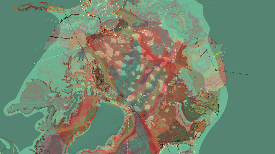
Map | melting ice – border claims — Where do the border claims of the five-nation Arctic states overlap? - data categorized into the melting of the ice, the claiming of territory, the border claims made by the surrounding nations and the emerging supranational organizations.

As the ice is melting, a new ocean is emerging. The first flag was planted in 2007 by Russia, an act that trans­formed the Arctic Ocean, a former terra incognita, into claimable territory. It didn’t have any legal con­sequences but memorized how European powers gained pos­session over terra nullius, demonstrates the colonial connotation of sovereignty and heated the tensions between the surrounding na­tion states of the ocean.

These promises of global warming transform the Arc­tic region into a site of intense geopolitical and in­frastructural intrigue with incompatible border claims made over the previously un­touchable landmasses. The immaterial nature of these claims currently constitutes a battleground for political and geographic conflicts. None of them is ratified yet, which allows us to re­think the current bioregion­al jurisdiction of the Arc­tic ocean and move towards a new form of networked geopolitics.

Medium:

Mapping, Gameplay, Animation
Gameplay | Third person — Oil spill | In 2020 one of the oil rigs in Verkhoyansk exploded and covered the Tern’s breeding grounds all along the Russian coast. This spill damaged the surrounding ecosystem, recovering from this event will take a long time due to the Arctic’s climatic conditions.
Gameplay | Perception
Map | Arctic Tern migration patterns - Natural resources — How do extractive processes harm other than human agents living in this environment? – data categorized into migration and breeding areas of the Arctic tern as well as oil reserves, and oil infrastructure.

From 2013 onwards, the re­gion is subject to a fierce geopolitical game of trade and sovereignty over the oil-rich waters, discovered via the recent international in­terest and investigations. The Arctic tern returns ev­ery April from Antarctica to the Arctic, finding its way via the magnetic field. Their breeding grounds are cate­gorized by virtual boundary lines advocated for by NGO’s, who aim to transform the Arctic region into a wildlife sanctuary.

The new knowledge about the richness of resources posi­tioned underneath the arctic ocean floor fuelled the in­terest in the region. With­in the international waters, the border claims aren’t settled yet, but within each country’s exclusive econom­ic zone, the first regula­tions around places to ex­tract came to rise, at these places’ multinationals set­tled large oil infrastruc­tures and started drilling into the ground.

Medium:

Mapping, Gameplay, Animation
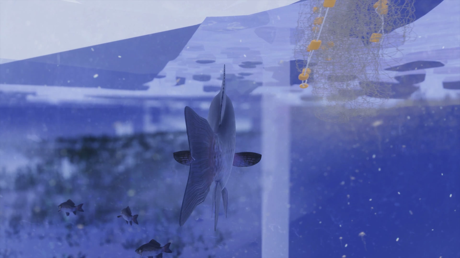
Gameplay | Arctic Cod - Third person — Melting ice | The recent melting led more sunlight penetrate into the wa­ter, it increased the production of plankton, the cod’s food and it coloured up their foggy living environ­ment, which make navigating easier. But at the same time, the thinner sea ice meant their resting places to hide from predators higher up the food chain, such as the arctic tern and shipping boats, are limited.
Gameplay | Arctic Cod - Perception
Map | Arctic Cod swimming patterns – The division of the marine regions — What is the relationship between overexploitation of the Arctic cod and division of the marine regions via political constructed borders? – data categorized into ocean features, marine areas, fishing regulations, and swimming patterns Arctic cod.

Traditionally, overfishing in the Arctic was not a ma­jor concern because of its ice cover, but the increas­ing melting asked for regu­lations, not only within the exclusive economic zones of each nation but also regard­ing the international wa­ters.

Nowadays, these high seas are open to anyone. In the absence of an agree­ment, fishing here is thus not illegal. Consequently, in the late 1980s, these wa­ters were crowded by fishing trawlers from Japan, China and elsewhere. They removed billions of tons of fish and placed the ecosystem in dan­ger. This overexploitation of the marine regions forced international organizations to map out and divide the dynamic landscape by politi­cal borders to limit the harm done to the ecosystem.

Medium:

Mapping, Gameplay, Animation
Gameplay | Third person — Arctic ports | The ports in the Arctic are human exclusion zones, guided by the met­rics of computation. They are micro­cosms formed by machines and operate irrespective of city regions and state jurisdic­tions. These landscapes are time materialized; they nev­er standstill, just as time, they are in a constant state of becoming, which introduces the dynamic and global na­ture of border conflicts and asks for an alternative per­ception of state borders.
Gameplay | Perception
Map | The rise of shipping routes – Emerging logistical settlements dotted along the Arctic coast — How does the increase in shipping forms microcosms, regions in which multiple state borders overlap? - data categorized into sea and land transport, infrastructure, and state micro-jurisdictions.

The region is getting ready for the busiest shipping route in human history, the new silk route of the North. This boat is one element of this new geographical network, a network in which communication happens via infrastructure positioned anywhere, in the sea, sky, on the earth and even in space. It sees the environment via waves. It maps the empty ports and robot cities dotted along the coastline alongside the passing machines, operated by offices located thousands of kilometres to the South. It registers the political borders constructed by multiple state jurisdictions, which together form our continuous planetary network. Still, they don't listen to them.

Medium:

Mapping, Gameplay, Animation

Triggered by the promises of global warming, the Arctic is a site of intense geopolitical and infrastructural intrigue, with incompatible and interlocking border, claims rooted in colonial and cartographic history. 

During my research, I discovered that these claims are political constructs with a liminal condition, presented via the current cartographic imagination that renders the world as Cartesian space. This arrangement of space is based on the location of bidimensional border lines. Lines decided by political decisions rather than scientific ones, which is why, especially in time of climate crisis, they lack the capacity to function as a suitable instrument to design and govern our world, exactly because they do not account for the complexities of the region.

Alternative Arctic perception constitutes an alternative cartographic representation for the Arctic. A region in which the climate radically transforms the geographic area as well as the geopolitical governance. The game lets you move through several geozones, which are transcontinental regions that defy the prevailing cartographic logics. By including global aspects apart from different meanings and histories of several agents, these zones aim to construct an alternative representation that accounts for the dynamic complexities of the Arctic landscapes.Ultimately, this game functions as a testing ground for a new visual strategy to communicate the liminal condition of politically constructed borders within the Arctic region.

Medium:

Mapping, Images, Visualization, Diagrams, Narratives